SATELLITE LAUNCH VEHICLES🛰️
Satellite Launch Vehicles.
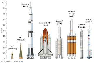
A rocket-powered vehicle used to transport a spacecraft beyond Earth's atmosphere, either to orbit around Earth or to some other destination in outer space.
In order to reach Earth orbit, a launch vehicle must accelerate its spacecraft payload to a minimum velocity of 28,000 km (17500 miles) per hour, which is roughly 25 times the speed of sound. To overcome Earth's gravity for travel to destinations such as the Moon or Mars, the spacecraft must be accelerated to a velocity of approximately 40,000 km (25,000 miles) per hour. The initial acceleration must also be provided very rapidly in order to minimize both the time that a launch vehicle takes to transit the stressful environment of the atmosphere and the time during which the vehicle's rocket engines and other systems must operate near their performance limits; a launch from Earth's surface or atmosphere usually attains orbital velocity within 8 –12 minutes.
Indian Satellite Launch Vehicles.
India launched its first Satellite in 1980 using the four-stage solid-fuelled Satellite Launch Vehicle 3 (SLV-3), which was developed from the U.S. Scout launch vehicle first used in 1960. India didi not have a prior ballistic missile program, but parts of SLV-3 were later incorporated into India's first IRBM, agni. The four-stage Polar Satellite Launch Vehicle (PSLV) was then developed; it used a mixture of solid- and liquid-fuelled stages. The first PSLV Launch took place in 1993. During the 1990s India developed rhe liquid- fuelled Geostationary Space Launch Vehicle (GSLV), which used cryogenic fuel in its upper stage. The GSLV was first launched in 2001. Both the PSLV and GSLV remain in service.
What Is A Launched Window?
A launch window is a precise period of time, ranging from minutes to hours, within which a launch must occur for a rocket or Space Shuttle to be positioned in the proper orbit.
Sometimes, this window is determined by the passing of an orbiting spacecraft with which the orbiter must rendezvous, such as the International Space Station or an ailing satellite. At other times, the Space Shuttle or an unmanned rocket must be launched with a certain window so that it can release its satellite payload at the right time to place it in an orbit over a certain region of Earth.
The Sriharikota Range Is The Second-Best Located Spaceport In The World, Why?
1. Location:
Located near to the equator, Sriharikota is the ideal launch site for geostationary satellites. Sriharikota is ideal for eastward launchers. SHAR's location on the east coast and shows that it gains an additional velocity of 0.4 km/s due to Earth's rotation to easily launch rockets. Most satellites are launched eastward. There is also a a proposal for a new launch pad at Kulasekarapattinam in 2013 which is ideal for southward launches.
2. Accessibility:
Their equipments are huge and travel from across the world. For this very reason, it must be accessible by all means of transport;
Land, Air,Water. Ate the same time, The site is prone for accidents. So, it should be remote away from inhabitants. Being a coastal island ares with no habitation proves advantageous for Sriharikota because it is on National Highway (NH-5), 20 km away from nearest Railway Station, and 70 kms (Chennai) from nearest International Ports by air and Ships.
3. Coastal Site:
You never know what falls off from a flying object. The maximum distance of impact from the launch site can be up to 6500 kms.
4. Climate:
Heavy rains come only in October and November allowing them to test outdoor for 10 months in an year. There is no bad day that a rainy day and Sriharikota offers you optimal rainfall.
It is no accident that Sriharikota is chosen. Sriharikota is not chosen among few options. It is THE OPTION for ISRO. Sriharikota silently played and playing it's role in making India proud ever since the "Rohini-125" sounding rocket was launched in 1971 helping 35/43 successful launches as of June, 2014.
Indian Regional Navigation Satellite System (IRNSS).
IRNSS is an independent regional navigation satellite system being developed by India. It is designed to provide accurate position information service to users in India as well as the region extending up to 1500 kilometre from its boundary, which is its primary service area. An Extended Service Area lies between primary service area and area enclosed by the rectangle from Latitude 30 degree South to 50 degree North, Longitude with 30 degree East to 130 degree West.
IRNSS will provide two types of services common, namely, Standard Positioning Service (SPS) which is provided to all the users and Restricted Services (RS) , which is an encrypted service provided only to the authorised users. The IRNSS System is expected to provide a position accuracy of better that 20 m in the primary service area.
THANK YOU.
Follow me on:


👍👍
ReplyDeleteAmazing
ReplyDelete